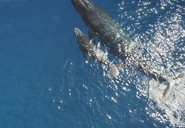
Surveillance Refined

We provide advanced, FAA approved, airborne monitoring solutions within the maritime environment. Whether you're seeking first flight light response, mammal detection, search and rescue assistance or something else, our services can be tailored specifically to your parameters empowering you to detect, analyze, react and resolve observed conditions with greater precision.

image of latest agricultural innovation
[background image] image of pipes and fittings
image of webinar setup
[background image] image of creative workspace (for a game development company)

Detect. Analyze. React. Resolve.

Airborne surveillance

Capture high-resolution imagery based on your search action plan for comprehensive monitoring and analysis.

AI-driven insights

We leverage advanced AI to filter based on the specification and perameters you outline.

Human verification

Analysts review flagged issues, ensuring only confirmed conditions are mapped for your team's review.

Interactive map access

View and manage observed conditions in a secure, password protected, map-based environment for more efficient, intelligence based decision-making.

Seamless reporting

Generate required forms and reports directly from the platform to streamline compliance and response.

Contact Us

Our Maritime Monitoring In Action

Dynamic Map Instructions (Delete This)

Don't delete "cru-ncf"-elements

Elements with “cru-ncf-…” classes contain essential attributes required for Dynamic Map to function properly. Please do not delete these elements.

Style in Webflow, modify in Dynamic Map App

Use the Dynamic Map App from Webflow’s App Store to adjust your map settings. All styling can be managed directly in Webflow. Refer to the Style Guide below the map to customize elements provided by Dynamic Map.

In case of an issue...

... open the Dynamic Map App, click “Refresh,” then “Insert Code,” and follow the provided instructions. If this doesn’t resolve the issue, refer to our Help Center for assistance.

Important Links

Dynamic Map App
Help Center
License Settings
About Dynamic Map for Webflow [by No Code Flow]
Reset Filter
Select the severity of the observed condition here:
Low
Medium
High
Critical
Thank you! Your submission has been received!
Oops! Something went wrong while submitting the form.
ENCROACHMENT
test22
EQUIPMENT
Test
BOAT
Non AIS
WHALE
NA
BOAT
Hazard
EQUIPMENT
construction
EQUIPMENT
Car
EQUIPMENT
Car
EQUIPMENT
Truck
ENCROACHMENT
Fishing
EQUIPMENT
Operations Inspection
BOAT
Small craft
EROSION
Storm damage
Unknown Vehicle
Car observed for review
Panthers
Wildlife observed around equipment
Unknown Person
Fisherman observed requiring review
Unknown Vehicle
Truck parked near site requiring review
Person Loitering
Person seen walking on site requiring review
Equipment Blocking Roadway
A large front end loader appears to be blocking the roadway
Group of People
A group of people are on the site requiring attention
Collapsed Outbuilding
It appears the wind may have blown over a small outbuilding
Flooding
Possible flooding in the area requiring review

Dynamic Map Style Guide (Don't Delete)

Please modify your styling elements here to change their appearance on the live website. The styleguide is invisible on the published site.

Condition Observed

Change the active state for your list item
Default State
List Item Default
Active State [add class "active"]
List Item Active

Filter Reset / Empty State

Style your empty state
There are no items using this filter combination.
Reset Filter

Pop-Up

Change Pop-Up style here. Hide in Dynamic Map App.

Tooltip (Don't Delete)

Change Tooltip style here. Hide in Dynamic Map App.
construction
View Image On Map
Operations Inspection
View Image On Map
Storm damage
View Image On Map
Car observed for review
View Image On Map
Wildlife observed around equipment
View Image On Map
Fisherman observed requiring review
View Image On Map
Truck parked near site requiring review
View Image On Map
Person seen walking on site requiring review
View Image On Map
A large front end loader appears to be blocking the roadway
View Image On Map
A group of people are on the site requiring attention
View Image On Map
It appears the wind may have blown over a small outbuilding
View Image On Map
Possible flooding in the area requiring review
View Image On Map

Filter Address Search

Change the active state for your address search
Default State
Thank you! Your submission has been received!
Oops! Something went wrong while submitting the form.
Active State [add class "active"]
Thank you! Your submission has been received!
Oops! Something went wrong while submitting the form.

Filter Chip

Change the active state for your filter chip
Default State
Filter Chip
Active State [add class "active"]
Filter Chip Active

Map Location Pin

Change pin style and states
Default State
Hover State [add class "hover"]
Active State [add class "active"]
image of agricultural machinery in use for agricultural services


Semi-Submersible Detection Capability

This video displays how, with our advanced aerial imaging, AI insights, and expert analysis, we assist you detect, analyze, react and resolve observed conditions with greater efficiency.

Marine Vessels At Sea

At any given time, there are 50,000 to 100,000 vessels at sea. This includes large merchant and cargo ships as well as smaller vessels. The button below will take you to a map which allows you to explore these vessels worldwide.
View Marine Vessel Information
image of latest agricultural innovation

Our Maritime Monitoring Plans

Select the plan that works best for you and your organization

Frequently Asked Questions

Which items are monitored through your surveillance plans?

Whether over water, along the coast or on land, we stand ready to assist you in detection and analysis so that you can determine when and how to respond and resolve the issue at hand.

How does AI flag observed conditions?

AI reviews captured imagery allowing us to filter for parameters you outline in your tasking. Human analysts review and confirm based upon your specifications before observed conditions appear within your mapped environment.

What does our access subscription  include?

Depending upon which plan you select and the specifications you provide, our team can provide interactive maps, near real-time alerts, reports, and integrated forms.

How are observed conditions managed?

Confirmed items are flagged for your review within your map environment. The decision to dismiss or escalate each item remains fully within your control.

Connect with our experts

Ready to get started or have questions about maritime surveillance or AI-driven insights? Our team is here to assist you.

Simply complete our contact form and we'll be in touch to discuss the specifications surrounding your monitoring needs.

Should you need to reach us right away, please call our support team at: 541-490-8332.

Also, remember to ask us about crowdfunding opportunities for future missions our team passionately supports.

Thank you. We’ll be in touch soon.
image of a customer service representative working in a digital interface environment [digital project]
Submission failed. Please review your details.